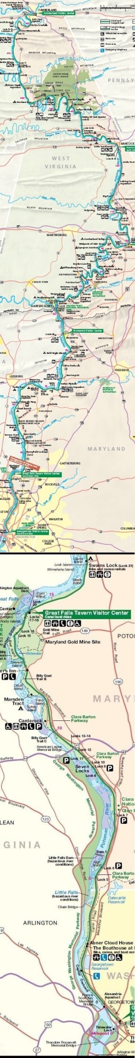
Park entrance

Access Points (via automobile)

This page lists access points for drivers along the towpath from Georgetown to Cumberland. The second column shows the milepoint along the towpath. The last column includes GPS coordinates and a link to Google Maps for directions. GPS coordinates were chosen to get drivers as close as possible to access points using roads recognized by Google Maps. Warning: your GPS device might not recognize the same roads as Google Maps.

Georgetown to Great Falls

Access PointMileNotesCoordinates
Georgetown0.0 - 1.1The canal is accessible from many points in Georgetown. Parking can be difficult during peak times in this popular neighborhood.38.904167, -77.060133
Google map
Fletchers Cove3.1Large parking lot38.918691, -77.102019
Google map
Chain Bridge4.0About 30 parking spaces along Clara Barton Parkway. The spaces sometimes fill up on busy days.38.932841, -77.112844
Google map
Brookmont footbridge5.0Take footpath off Ridge Drive downhill to the spiraling footbridge over the parkway, which brings you to the downstream end of the picnic area at Lock 5.38.939982, -77.120157
Google map
Lock 65.4About 15 parking spaces along Clara Barton Parkway. The spaces sometimes fill up on busy days.38.944737, -77.123348
Google map
Valley Road (Brookmont)5.4At the end of Valley Road, follow a footpath which leads across the parkway at grade, just upstream from Lock 6.38.945460, -77.122672
Google map
Sycamore Island6.4About 15 parking spaces along Clara Barton Parkway. The spaces sometimes fill up on busy days.38.95832, -77.131465
Google map
Walhonding Road footbridge6.4Parking lot with 20 spaces on MacArthur Boulevard. Take footpath to the spiraling footbridge over the parkway.38.958303, -77.130849
Google map
Lock 77.0About 10 parking spaces along southbound Clara Barton Parkway. The spaces sometimes fill up on busy days.38.964611, -77.138363
Google map
Cabin John Aqueduct7.7About 10 parking spaces along MacArthur Boulevard. Cabin John Trail leads 0.4 miles down to the towpath.38.972854, -77.147357
Google map
Lock 88.3Parking spaces along southbound Clara Barton Parkway. The spaces sometimes fill up on busy days.38.971559, -77.160636
Google map
Riverside Drive8.3No parking area. Follow path at end of road to Lock 8.38.972080, -77.162100
Google map
Lock 108.8Parking spaces along southbound Clara Barton Parkway. The spaces sometimes fill up on busy days.38.972631, -77.169278
Google map
Carderock10.4 - 10.8Large parking lot runs parallel to the towpath.38.974560, -77.201968
Google map
Marsden Tract11.4Small parking area—space for three cars. Follow footpath to bridge across canal.38.978697, -77.215888
Google map
Old Angler's Inn12.2Ongoing construction work has reduced parking available at this popular location.38.981897, -77.226205
Google map
Great Falls14.3 Large parking lot39.001748, -77.246836
Google map

Great Falls to Harpers Ferry

Access PointMileNotesCoordinates
Great Falls14.3Large parking lot39.001748, -77.246836
Google map
Swains Lock16.6Small parking lot39.031634, -77.243531
Google map
Pennyfield Lock19.6Parking lot39.054972, -77.290334
Google map
Violettes Lock22.1Parking lot39.067226, -77.328483
Google map
Rileys Lock22.8Large parking lot39.069167, -77.340877
Google map
Sycamore Landing27.2Parking lot39.074731, -77.420193
Google map
Edwards Ferry30.8Parking lot near boat ramp39.103463, -77.472933
Google map
Whites Ferry35.5Large parking lot39.154861, -77.518206
Google map
Dickerson Conservation Park39.6Parking lot39.194685, -77.469402
Google map
Monocacy Aqueduct42.1Parking lot39.222563, -77.449987
Google map
Nolands Ferry44.6Small parking lot39.249948, -77.482726
Google map
Point of Rocks48.2Parking lot near boat ramp39.273218, -77.540045
Google map
Lander50.9Parking area near lockhouse39.306507, -77.558006
Google map
Brunswick55.0Parking lot39.311220, -77.630749
Google map
Weverton58.0Use caution crossing the railroad tracks. Trains go through this area very rapidly.39.329916, -77.681966
Google map

Harpers Ferry to Williamsport

Access PointMileNotesCoordinates
Maryland Heights61.3About 10 spaces available at the trailhead on north side of Harpers Ferry Road. Use footbridge to access towpath.39.329395, -77.731919
Google map
Lock 3461.6Best used for drop off or pick up. No more than three cars can park legally.39.333430, -77.738577
Google mapGoogle map
Dargan Bend64.9Parking lot near boat ramp39.364182, -77.740073
Google map
Mountain Lock67.0Small parking lot39.385295, -77.734451
Google map
Antietam69.5Parking spaces along Canal Road, which runs parallel to canal for next three miles39.419001, -77.74657
Google map
Railroad bridge (Shepherdstown)72.4Large parking lot on Canal Road near the railroad trestle39.433927, -77.795512
Google map
Lock 38 (Shepherdstown)72.8Small parking lot near Route 34 bridge39.436456, -77.799527
Google map
Snyders Landing76.7Parking lot near boat ramp39.465270, -77.777313
Google map
Taylors Landing81.0Parking lot near boat ramp39.499645, -77.767866
Google map
Dam No. 484.4Small parking lot39.496001, -77.826266
Google map
Big Slackwater Boat Ramp85.4Large parking lot39.501346, -77.845385
Google map
McMahons Mill88.1Small parking area39.530654, -77.823522
Google map
Spring Dell Road89.1No parking. Pick up or drop off only. Follow path 500 feet past red barn to towpath.39.530309, -77.844116
Google map
Lock 4499.3Parking lot39.595037, -77.824712
Google map
Williamsport Visitor Center99.8Large parking lot39.600996, -77.826927
Google map

Williamsport to Hancock

Access PointMileNotesCoordinates
Lock 4499.3Parking lot39.595037, -77.824712
Google map
Williamsport Visitor Center99.8Large parking lot39.600996, -77.826927
Google map
Gift Road103.3Dirt road for last tenth of a mile. Small parking area near towpath.39.616863, -77.888503
Google map
Dam No. 5 Road106.2Limited parking along road39.604678, -77.911877
Google map
Dam No. 5106.8Parking lot39.607079, -77.921117
Google map
Lock 46107.4Small parking area near lock. If the gate is closed you many need to park on Dam No. 5 Road and walk 400 feet to the towpath.39.615866, -77.926626
Google map
Four Locks108.8Large parking lot39.615311, -77.947494
Google map
McCoys Ferry110.4Parking lot near boat ramp39.609261, -77.970065
Google map
Fort Frederick112.4Limited parking at towpath. Parking lot available at the fort, 0.3 mile away.39.605391, -78.005041
Google map
Ernstville Road114.5Very limited parking. Do not block gate.39.632970, -78.028951
Google map
Licking Creek116.3Parking area. Use Mile Marker Road off Route 40.39.655987, -78.053946
Google map
Little Pool119.6WMRT parking lot39.684430, -78.103796
Google map
Hancock Visitor Center122.8Turn south off Route 144.39.694227, -78.154046
Google map
Hancock124.1Easy access to towpath for a quarter-mile in cental Hancock. Large parking lots.39.698253, -78.181036
Google map

Hancock to Paw Paw

Access PointMileNotesCoordinates
Hancock Visitor Center122.8Turn south off Route 144.39.694227, -78.154046
Google map
Hancock124.1Easy access to towpath for a quarter-mile in cental Hancock. Large parking lots.39.698253, -78.181036
Google map
Berm Road125.6Road parallels canal from Hancock to this point.39.683618, -78.199002
Google map
Cohill Station130.7Small parking area.39.645446, -78.251711
Google map
Pearre Road, Dam #6134.0Limited parking. Do not block gate. Walk 0.4 mile east on WMRT to access towpath at Dam #6.39.628174, -78.298256
Google map
WMRT Pearre parking lot135.9Large parking lot. To access towpath, use an informal path across prism or walk 0.3 mile west on WMRT to Lock 56.39.636480, -78.323262
Google map
Lock 56 (Pearre)136.2Small parking area39.637868, -78.328302
Google map
Little Orleans140.8Parking available alongside form railroad embankment on nearby road.39.625648, -78.385868
Google map
Kasecamp Road147.1Unpaved road. Park near gate alongside former railroad embankment. Walk past gate to reach canal. If conditions aren't too wet, you should be able to cross prism near railroad bridge.39.603639, -78.425820
Google map
Bonds Landing150.1Unpaved road. Some potentially muddy parking at towpath. More parking near boat ramp.39.582848, -78.411246
Google map
Roby Hollow151.2Difficult access point. Very limited parking. Unpaved road. You must walk through Culvert #208 (which could be wet) to reach towpath.39.590113, -78.429294
Google map
Twigg Hollow153.3Outdoor Club Road is unpaved and may not be suitable for your family sedan. Parking at Green Ridge Forest campsite #66. Follow sign for Great Eastern Trail to reach towpath.39.58128, -78.46154
Google map
Paw Paw Tunnel156.2 Parking lot39.544450, -78.460806
Google map

Paw Paw to Cumberland

Access PointMileNotesCoordinates
Paw Paw Tunnel156.2Parking lot39.544450, -78.460806
Google map
Lock 67161.9Turn south off Route 51 at brown sign for "Town Creek Aqueduct" onto former WM rail right-of-way. Limited parking. Do not block gate. Footpath crosses prism.39.52560, -78.53626
Google map
Town Creek Aqueduct162.3Turn south off Route 51 at brown sign for "Town Creek Aqueduct" onto former WM rail right-of-way. Park at end of road. Follow footpath down to aqueduct.39.523862, -78.543122
Google map
Oldtown (Lock 70)166.7Parking lot39.540405, -78.611936
Google map
Spring Gap173.3Parking lot near boat ramp39.564306, -78.719289
Google map
North Branch175.6Parking lot near Lock 7539.587698, -78.743462
Google map
River Road176.4Small parking area39.587303, -78.754629
Google map
Mexico Farms178.3Limited parking39.599369, -78.750544
Google map
Brehm Road178.9You may be able to park on the road shoulder nearby.39.603402, -78.741713
Google map
Candoc Recreation Area181.8Parking available nearby in park.39.625274, -78.759307
Google map
Canal Parkway182.6No pulloff area or parking. Path leads down from bridge to towpath.39.622741, -78.773223
Google map
Elizabeth Street183.1Limited parking39.629393, -78.773132
Google map
Cumberland Visitor Center184.5Large parking lot39.649348, -78.762800
Google map