
Benjamin Latrobe’s Potomac Marble Quarries

by Paul Kreingold, Leesburg, VA
December 19, 2019

Introduction

The destruction of Washington D.C. in August, 1814 by the invading British challenged President Monroe and Benjamin Latrobe with the task of rebuilding the edifices which had been destroyed.  As did Washington and Jefferson earlier, they understood that the principal buildings of the government were not mere offices but symbols of the aspirations of the Republic. They had to be more than functional, they had to be beautiful. As classicists, their notions of beauty were derived from the ancient Greek and Roman Republics. Like the Greeks and Romans, the preferred building material was marble. The question was, where was such building material to be found?

In a report to the Committee on Public Buildings on November 28th, 1816, Benjamin Latrobe describes a stone which is a “very hard but beautiful marble” which “has been proved to answer every  expectation that was formed, not only of its beauty, but of its capacity to furnish columns of any length, and to be applicable to any purpose to which colored marble can be applied.“ Latrobe continues, “The quarries are situated in Loudoun county, Virginia and Montgomery county, Maryland.”(1)

Benjamin Latrobe
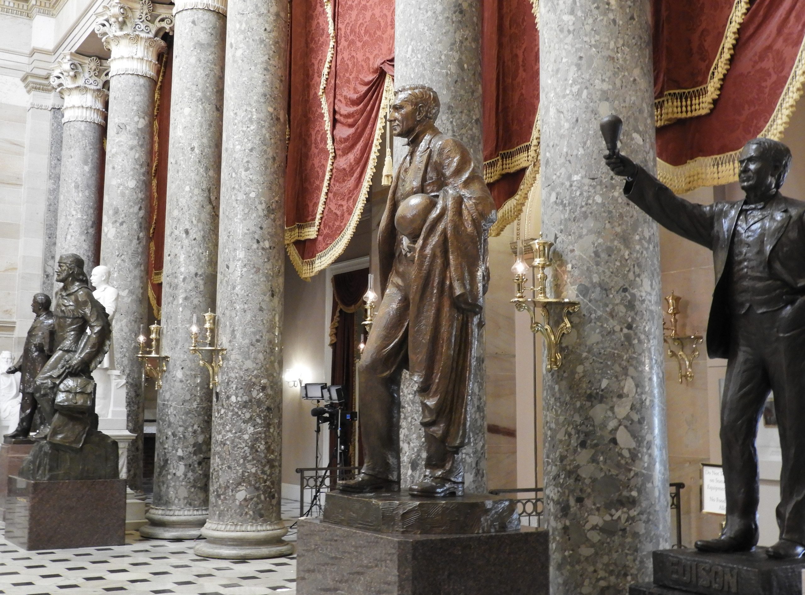
Latrobe is describing Potomac Marble which is a ubiquitous limestone conglomerate whose deposits stretch from south of Leesburg, Virginia to the shores of the Potomac River in Montgomery County, Maryland. It is not actually marble, which is metamorphosized limestone, but a sedimentary conglomerate consisting of pebbles of various sizes and composition (clasts) held together by a limestone (calcium carbonate) matrix. Ultimately, Potomac Marble was used by Latrobe for the columns in the Capitol’s old House and Senate Chamber. The unique characteristic of this marble is its color described here by Latrobe: “as the Cement which unites the pebbles does not receive quite so high a polish as the pebbles themselves, the Mass acquires a spangled appearance, which adds greatly to the brilliancy of its effect.”(2)  Visitors to the old Senate and House Chamber (Statuary) can still wonder at the beauty of these columns now two-hundred years old.

In Loudoun County, Virginia and Montgomery County, Maryland

The investigator who desires to search for the remains of the Potomac Marble quarries “in Loudoun county, Virginia and Montgomery county, Maryland” will find himself quite frustrated as the specific locations are never revealed by either contemporaries or those that write about them.  The mystery starts quite early. For example, Samuel Lane, the Commissioner of Public Buildings lists a disbursement dated May 21, 1816 for $16.00 for “Hack hire to marble quarries” and another paid to Latrobe for $161.27 for “Expenses exploring marble quarries.” (3)  Which marble quarries? Who owns them? Where are they?

Latrobe’s biographer Talbot Hamlin in his six-hundred-page work makes no attempt to identify quarry locations and only repeats a story told by Latrobe’s son about the discovery of the marble on the Loudoun estate of Samuel Clapton.  He implies that the quarries were on this estate but there is no other proof of this and much of the rest of the story is apocryphal. (4)

Other historians write that the marble came from the “banks of the Potomac River, just above Conrad’s Ferry”;(5) “both sides of the Potomac River in Loudoun County, Virginia and Montgomery County Maryland”;(6) and “in Loudoun County Virginia.”(7)

Cartographers are not any clearer. For example, a much-quoted early Loudoun cartographer, Yardley Taylor while discussing Potomac Marble in his 1858 Memoir of Loudoun County says, “This rock was used for the pillars in the Capitol at Washington, and may be seen in the Representatives Hall and Senate Chamber.”(8)  Mr. Taylor never identifies a Loudoun quarry location even on his 1853 map which is the first detailed map of Loudoun County and can be seen at the Balch Library in Leesburg.

Geologists are no exception. The 1898 Maryland Geological Survey reports, “There is some doubt as to the exact location of the particular source of these blocks used in the capitol.” (9)  Joseph K. Roberts writes in his 1928 book, the Geology of the Triassic:

“The rock was first noted by B.H. Latrobe who selected it for columns in the National capitol. It would seem from Latrobe’s account that the quarries from which the stone was taken were located in Loudoun County, Virginia and in Montgomery County, Maryland.”(10)

There is that phrase again!

Loudoun historian and mapmaker Eugene Scheel suggests two locations in Loudoun which may have been sources of Potomac Marble for Latrobe. These are Olde Izaak Walton Park and the Leesburg Limestone Quarry both in the town limits of Leesburg.(11) These are real possibilities but require more investigation. It should be noted that Scheel identifies the pond at Olde Izaak Walton Park as the filled in quarry. I have mapped the depth of that pond and nowhere is it more than seven feet deep. Additionally, I have photographs from 1955 of Izaak Walton members digging that pond. (12) The actual quarry in that park is about 200 yards south of the pond hidden by trees and poison ivy.

Government publications do not provide much more help. In a pamphlet published in 1975 by the U.S. Department of Interior, Building Stones of Our Nation’s Capital, it is written: “Until the Chesapeake and Ohio Canal was finished, the huge blocks were brought overland from quarries near Point of Rocks, Maryland, 46 miles west of Washington.”(13) Interestingly, when that pamphlet was re-published in 1998 it was ten pages smaller and only says that Potomac Marble came from “various localities.”(14)

There is, on the Chesapeake & Ohio Canal towpath a Marble Quarry Campsite at milepost 38.2. On the C&O Canal Trust web page it is described as follows:

“According to old maps, before the C&O Canal was built, there was a ‘Marble Quarry’ running along the Maryland side of the river for over a mile. The stone that was quarried here was known as ‘Potomac marble,’ which wasn’t a solid substance, but rather was composed of angular pebbles held together by a limestone matrix. Benjamin Latrobe discovered Potomac Marble with its varied and rich colors and made the decision to include it in the Capitol buildings he was designing. (15)”

I have found no evidence of a quarry near this campsite.

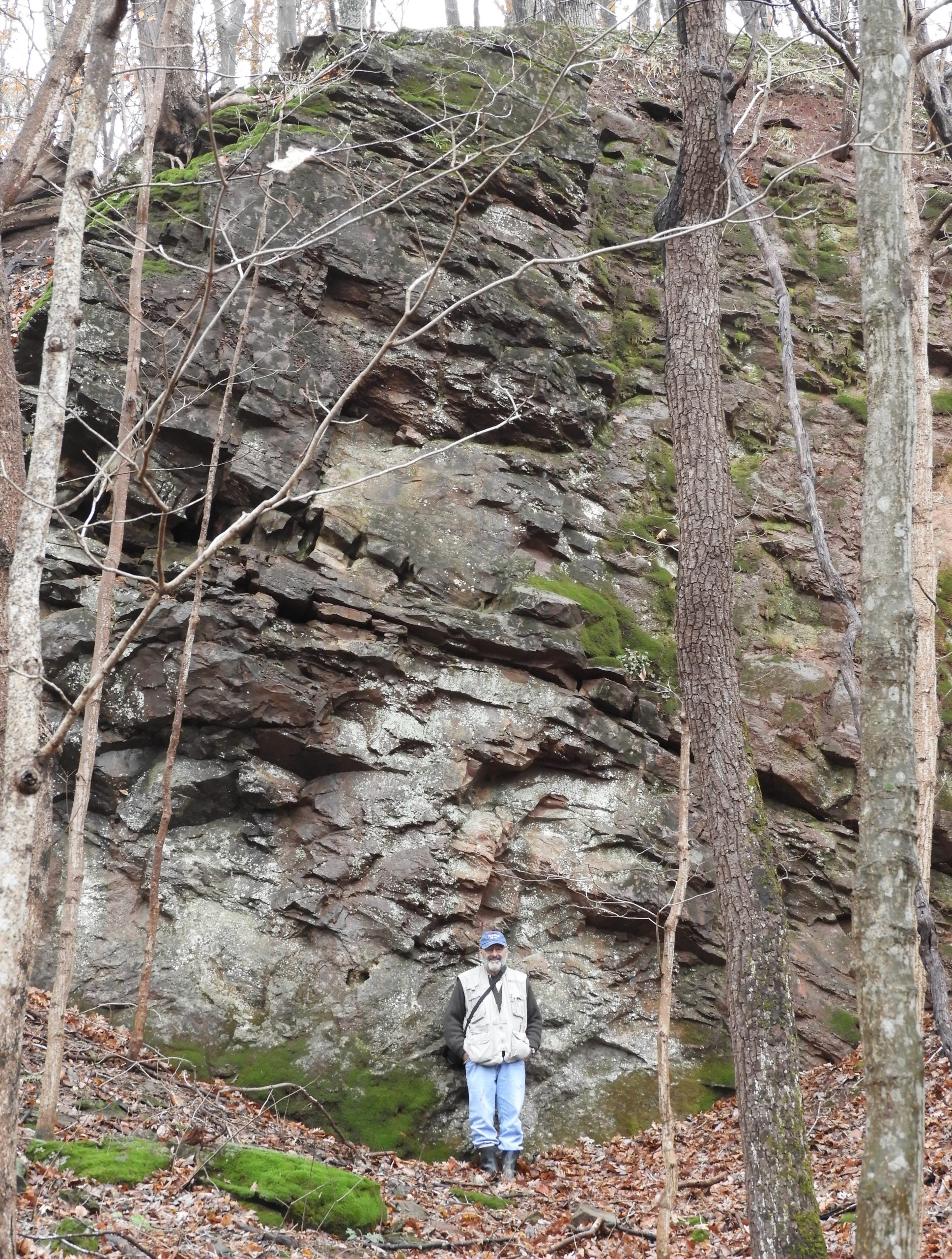
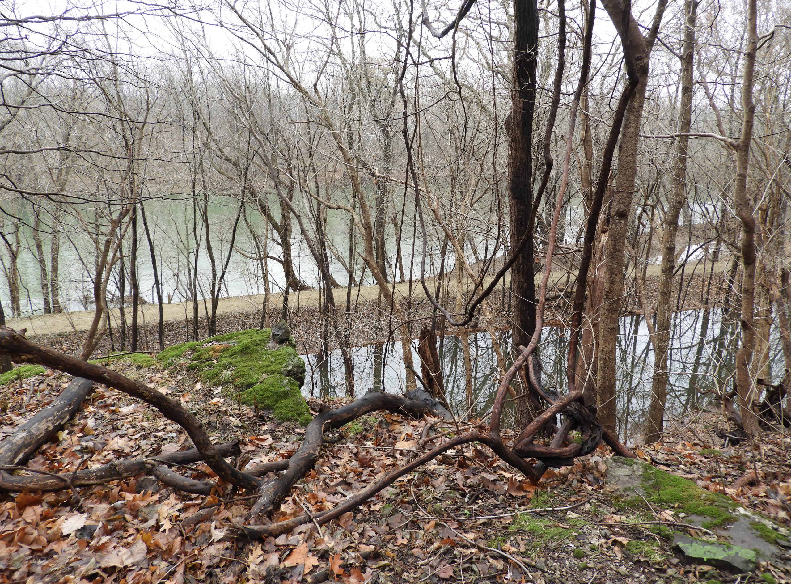
This leads us to ask, “Doesn’t there exist at least one two-hundred-year-old hole-in-the-ground which we can prove was a source of the Potomac Marble for the columns in the Capitol?”  Now, at last, we can answer, “Yes, there is!” It is located 2.2 miles upriver from White’s Ferry on the C&O Canal towpath, at milepost 38. Its coordinates are 39.177192, -77.4960702.

The Investigation

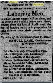
In the April 8th, 1817 issue of the Genius of Liberty, a local Leesburg, Virginia paper there is an advertisement which reads:(16)

Newspaper ad
Wanted Immediately.
At the Marble Quarry, Montgomery County,
Maryland, on the Potomac,

ONE HUNDRED STRONG, HEALTHY,
Laboring Men
To whom liberal wages will be given, and
for strong and healthy negro men Ninety
Dollars
from the first of April until the
first of January next; or in proportion for
such time as they shall remain at the
Quarry.
By order of the President of the U. States.
SAMUEL LANE, Commissioner
of the public buildings

APPLY TO
John Nelson, esq. Frederick Town,
John Littlejohn, esq Leesburg,
John Hartnett at the Quarry,
Joshua Shelton, near Conrad’s ferry,
Major Noland, at Aldie (Loudoun)
Samuel Clapham, esq
The printer of the paper, Alexandria
And the Commissioner of the public
buildings at Washington
March 28th

All of the men listed were important in their communities and many of them had a direct relationship to Latrobe and the rebuilding effort in the capital.  For example, according to Eugene Scheel, John Littlejohn was a Methodist Minister and sheriff in Leesburg and was part of the chain that preserved the Constitution and other important state papers which were hurriedly removed from Washington for safe-keeping immediately before the burning in the summer of 1814.(17)

John Hartnett (“at the quarry”) was an experienced stone mason who was placed in charge of shaping the Potomac Marble columns when they arrived in Washington. According to an article in the National Intelligencer of January 24, 1817, in June of 1816 Commissioner Samuel Lane contracted with Mr. Hartnett, “an experienced marble mason, for all the columns and pilasters of the House of Rep…”(18)

Most important, though, is Samuel Clapham. The Clapham family were active in Loudoun county for generations, involved in farming, quarrying and canals. Their estate house, named Chestnut Hill still stands just west of Route 15 in northern Loudoun County. It was Samuel Clapham who owned the land leased by the U.S. government in 1817 for the first Potomac Marble quarry. In an August 8, 1815 letter to the Commissioners of the Public Buildings, Latrobe identifies Clapham:

“There is on the S. East of the Catocktin Mountain a very large extent of country, which abounds in immense Rocks of Marble, or Limestone Breccia, that is of a Stone consisting of fragments of ancient Rocks bound together by calcareous cement, and thus becoming one solid and uniform (homogeneous) Mass of Marble. This Range of Rocks I have traced from James river to the Delaware, but it appears nowhere of a more beautiful kind then on the Patowmac. A specimen will be submitted to you as soon as I can get it polished.”

“The largest Mass of this Kind of Rock is situated on the Maryland side of the Patowmac [sic] on land the property of Samuel Clapham, Esqr. It overhangs the River, and would furnish without any land carriage all the Columns of the Capitol of one block each if required, and of beauty not exceeded in any modern or ancient building.”(19)

In February of 1816 the Commissioners contracted with Samuel Clapham to quarry the marble. (20)   On March 14, 1816, Latrobe sketched the outcrop and titled the piece, “Breccia Marble Rock opposite Clapham Island.”(21) Clapham Island is now called Mason Island and is about 1.5 miles long with its up-river end directly across the Potomac river from the Marble Quarry campsite mentioned above.

All of this evidence, and more, pointed to the location of a quarry in a 1.5 mile stretch along the Maryland shore of the Potomac River across from Mason Island but a search by your author in the Autumn of 2018 failed to find one.

The Actual Hole-in-the-Ground

In 2018, while researching the history of Potomac Marble, Mary Oehrlein, a Historic Preservation Officer at the Capitol became an important resource. Among other items, she sent a memorandum dated January, 1965 and written by Owen H. Ramsburg an engineer employed by the Office of the Architect of the Capitol (AOC). It was addressed to Mario E. Campioli the Assistant Architect of the Capitol and the man in charge of restoration of the old Senate Chamber. It reads, “This investigation and report was made in order to find similar marble to be used in the restoration of the Old Senate Chamber.”(22)

In an attempt to locate “similar marble”, Mr. Ramsburg consulted some many of the same sources I had used only to find the same ambiguous results. At first, thinking that the Point of Rocks area was the probable location of the quarry, Mr. Ramsburg made multiple visits to the area. in particular visiting Camp Kanawha, a private club, which still exists.(23) Potomac Marble samples were taken at the Camp and along the nearby Baltimore and Ohio Railroad tracks. In all, three visits were made to this area between October and December 1964 by Mr. Ramsburg and Frank X. Kuhn, a stone expert employed by the AOC. The men remained unsatisfied that the source of the marble columns was there.

The investigation received critical evidence when Benjamin Latrobe’s article in the National Intelligencer from January 24, 1817 was located by Ramsburg. In this article, Latrobe writes,

“The Potomac, breaking through the Cotecktin [sic] mountain, crosses the Breccia until it meets the Monocasy [sic] under the S.E. side of the valley; it then suddenly turns to the S.W. and again enters the Breccia, leaving a large mass on the Maryland side (the east side) of the river, by far the highest part of this irregular compound. It immediately however turns to the S.E. and at Conrad’s Ferry (now White’s Ferry, PK) leaves the Breccia finally. On this high mass in Maryland, in which the quarry is opened.”(24)

Further search in this “high mass in Maryland” above White’s Ferry revealed that the land was broken up roughly into two bluffs with a deep ravine between them. A thorough search was made of the area but to no avail. Finally, National Park Service rangers were mobilized in January 1965 and an expedition organized. On February 1, 1965 Chief Ranger Bell of the National Park Service announced they had located the quarry 2.2 miles upriver from White’s Ferry.

Visiting the Quarry

It took two attempts on my part to find Latrobe’s quarry despite the specific instructions of the Ramsburg report. (25)  The quarry is impossible to see from the towpath when there are leaves on the trees and difficult when there are none. Using an accurate GPS device, walk up river on the towpath from White’s Ferry. The river will always be on the left and in a mile or so the farm land on the right gives way to a growing stone ridge. The occasional drill marks in the ridge are from the canal construction and are not relevant to our search. The quarry is located at the top of this ridge at exactly 2.2 miles. Fortunately, the canal is shallow in this area and can be easily crossed but wading boots are recommended. Climb the ridge and enter the quarry. Over fifty years later, it is exactly as described in the report by Mr. Ramsburg:

“Some of the sides of the quarry show drill marks as do one or more blocks laying loose in the bottom of the quarry. The south wall or side of the pit is practically solid Potomac marble. The east wall has two to eight feet or more thick seams of the red sandstone of the Newark formation between which are seams of Potomac Marble. On the north side, the bottom of the pit, in general, meets the natural slope of the bluff and at the west side the floor of the pit drops off abruptly to the canal below.”(26)

Interestingly, during a search along the water’s edge in the immediate area of the quarry some marble blocks were found half-buried in the mud.(27) Was this the result of a careless boatman loading the cargo back in 1817 or simply debris scattered from the quarry above over a 200-year period? Further investigation is needed.

And What About the Loudoun Quarries?

Having successfully located the main Montgomery County Potomac Marble quarry the search for a Loudoun County quarry continues. As I indicated earlier, there are at least two locations which oral history point to as possibilities, but documentary proof is still needed.

Paul Kreingold
Conservation Director, Loudoun County Chapter, Izaak Walton League of America
Virginia Master Naturalist, Banshee Reeks Chapter, Leesburg, VA

Old House Chamber of Capitol

Potomac Marble Columns in the Old House Chamber of U.S. Capitol

East Wall of the Potomac Marble Quarry

Author standing in front of East Wall of the Quarry

View of the Potomac from quarry

View of the Potomac from Quarry

Footnotes:

1. American State papers, Class 10, Misc II Image 427, City of Washington: Progress Made in Rebuilding the Public Edifices, Latrobe Report to congress, November 28, 1816
https://memory.loc.gov/cgi-bin/ampage?collId=llsp&fileName=038/llsp038.db&recNum=440&itemLink=r%3Fammem%2Fhlaw%3A%40field%28DOCID%2B%40lit%28sp0382%29%29%230380007&linkText=1

2. Saul K. Padover, ed., Thomas Jefferson and the National Capital (Washington, DC: United States Printing Office, 1946), 483, Latrobe letter to Thomas Jefferson, June 28 1817.

3. American State papers, Class 10, Misc. II Image 434, Abstract of Disbursements made by Samuel Lane, December 12, 1816
https://memory.loc.gov/cgi-bin/ampage?collId=llsp&fileName=038/llsp038.db&recNum=447&itemLink=r%3Fammem%2Fhlaw%3A%40field%28DOCID%2B%40lit%28sp0382%29%29%230380007&linkText=1

4. Talbot Hamlin, Benjamin Henry Latrobe (New York, Oxford University Press, 1955), 444.
The story told by John H. Latrobe is reported on page 64 of his biography, John H. Latrobe And His Times 1803–1891 (Baltimore: The Norman Remington, 1917). The apocryphal nature of the story is that John says that it was at the Clapham estate that his father “saw for the first time the Breccia from which the columns of the House of Representatives…were afterward obtained.” However, Benjamin Latrobe in his January 18, 1817 letter to the National Intelligencer says, “It is now about 20 years…” since he first noticed Potomac Marble.

5. Robert Kapsch, Building Washington (John Hopkins University Press, 2018), 218.

6. William Allen, History of the United States Capitol (U.S. Government Printing Office, Washington 2001) 106.

7. Paul Norton, Latrobe, Jefferson and the National Capitol (Garland Publishing Company, New York, 1977) 241.

8. Yardley Taylor, Memoir of Loudoun County Virginia, (Thomas Reynolds, Leesburg, 1858)

9. Maryland Geological Survey, Vol. II (Johns Hopkins Press, Baltimore,1898), 187–193.

10. Joseph K Roberts The Geology of the Virginia Triassic, (University of Virginia, 1928) Page 130 https://www.dmme.virginia.gov/commercedocs/BUL_29.pdf

11. Eugene Scheel, History of Loudoun’s Limestone Overlay District
https://www.loudounhistory.org/history/limestone-overlay-district/
Note the article incorrectly states that Potomac marble was used for the capital from 1793 to 1817.  It was actually used only after the 1814 fire beginning in 1817.

12. Thank you to Master Angler David Crenshaw of Leesburg, Virginia for helping me measure the depth of the pond using his Deeper Sonar device. The photographs of the pond construction were provided by Dan Davis, the Education Director of the Loudoun Country Izaak Walton League. He received them in a letter dated March 10, 2015 from Mr. Tom Caviness whose father Jack Caviness was a charter member of the organization.

13. Building Stones of Our Nation’s Capital, (Department of Interior, Washington DC, 1975), 12.
https://pubs.usgs.gov/gip/70039206/report.pdf

14. Building Stones of Our Nation’s Capital (Department of Interior, Washington DC, 1998), 8.

15. https://www.canaltrust.org/pyv/marble-quarry-campsite/

16. Genius of Liberty, April 8th, 1817. https://virginiachronicle.com/?a=d&d=GL18170408-02.2.5.2&srpos=4&e=——181-en-20–1–txt-txIN-potomac+marble——-
Thank you to historian Edward Spannaus of the Lovettsville Historical Society for locating this advertisement which was reprinted many times in local newspapers.

17. Eugene Scheel, In Debate About Documents’ Hiding Place, A Loudoun Legend Lives On, (Washington Post, August 18, 2002)
https://www.washingtonpost.com/archive/local/2002/08/18/in-debate-about-documents-hiding-place-a-loudoun-legend-lives-on/d39e399b-816c-48b7-9627-4480e4c98e73/

18. National Intelligencer, January 24, 1817. Latrobe letter to the editor dated January 18, 1817. Library of Congress Newspaper collection.

19. Edward C. Carter II, Editor in Chief, The Papers of Benjamin Henry Latrobe, Series IV, (Yale University Press, New Haven, 1988), 681

20. Benjamin Latrobe, letter to Congress, November 28, 1816 (American State Papers, Miscellaneous, Volume II) 427,
“The present Commissioner of the public buildings has, therefore, entered into a contract for all the columns and progress has been made in quarrying them.”

21. Edward C. Carter II, Editor I Chief, Latrobe’s View of America, (Yale University Press, New Haven, 1985), 336.

22 . Owen H. Ramsburg, Report on Potomac Marble (United States Congress, Architect of the Capitol, Records, Office of the Curator, Washington, DC, Capitol Stone files, 1965), 1.

23. Camp Kanawha has a six-foot high Potomac Marble obelisk near its gate and uses the stone for some if its chimneys. Except as borders for gardens, this is the only use of Potomac Marble beside the columns in the Capitol that I have so far seen. I am indebted to Dr. George Lewis for guiding me through this area.

24. National Intelligencer, January 24, 1817. Latrobe letter to the editor dated January 18, 1817. Library of Congress Newspaper collection.

25. On the successful second attempt I was accompanied by Dr. Roger Biraben of Hillsboro, Virginia who greatly aided me in the search.

26. Owen H. Ramsburg, Report on Potomac Marble (United States Congress, Architect of the Capitol, Records, Office of the Curator, Washington, DC, Capitol Stone files, 1965), 1.
Although Ramsburg says that there is “no trace of blue overlying limestone described by Latrobe”, I did find some scattered on the floor of the quarry.

27. These stones were first noted by Jon Wolz who is a volunteer level-walker for the C&O Canal Association and an avid historian.